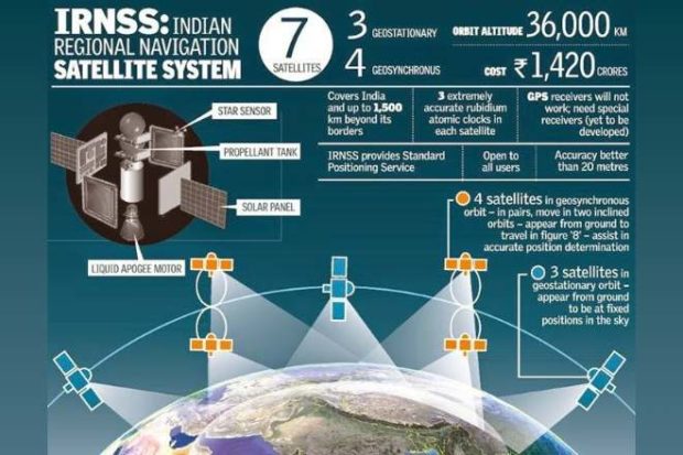
Did you heard about Indian GPS System? Right, you heard it rightly because recently Indian space agency ISRO launch made in indian Navigation system for mobile phones, cars, etc. But Are ISRO’s Made-In-India Navigation for Indian Cars, Better than USA’s GPS? Let’s check out some facts and comparison with between GPS, Glonass and IRNSS(NaVIC) for India. While GPS and GlONASS (Russia) still use the L1 band, the IRNSS use the L5 band, with 11 satellites orbiting India and 1500kms that surround it, while there is still some time before this technology comes to mobile phones it will find a place in India’s Automotive Industry as VTS with NaVIC could soon be made mandatory.
What is NavIC or Made in India Navigation System?
When you use Google Maps on your Android device or iPhone then you are using Global Positioning System (GPS) satellite navigation system. While GPS is very popular among smartphone users, what most people do not know is that GPS is not the only satellite navigation system. Russia uses its own GLONASS while the European Union and China have Galileo and BeiDou Navigation Satellite System (BDS).
India could soon be mapped and navigated, independent of the US-based GPS or the Russia based Glonass navigation satellites. The India Space Research Organization’ (ISRO) Indian Regional Navigation Satellite System (IRNSS) that goes by the operational name NaVIC, will soon be able to transmit to some navigation devices in India.
A strong contender in the semiconductor industry Ramakrishna Electro Component or REC have launched a Vehicle Tracking System or Module, that can relay signals from the ISRO IRNSS satellite.
Why is Indian regional navigation satellite system (irnss) needed how does it help in navigation?
The answer dates back to the 1999 Kargil War when US refused to provide vital GPS information about Pakistani troops to India, the need for having India’s own satellite navigation system was felt for the first time. After two-decades, Isro is now in talks with chipmakers to integrate NavIC in upcoming smartphones that will be sold in India.
Fast Facts about ISRO’s NavIC
- Prime Minister Narendra Modi in 2016 launched NavIC satellite navigation system made by Isro.
- Isro is already in talks with Qualcomm and Broadcom to integrate support for NavIC in smartphones.
- A new chip with NavIC support needs to be made for smartphones. Few OEMs are in talks with Qualcomm and Broadcom.
- NavIC-enabled smartphones will be a game changer for India as it is one of the biggest smartphone markets globally.
- NavIC only focuses on India and Isro considers it to be more accurate than GPS with position accuracy of 5 metre.
- NavIC is powered by dual frequency (S and L bands) while GPS is dependent only on L band making it more accurate than GPS.
- NavIC can also offer visual turn-by-turn voice navigation for drivers.
- There are a total of 8 Indian Regional Navigation Satellites (IRNS) for NavIC.
- Indian Air Force to use NavIC in fighter jets for navigation requirements.
- Commercial vehicles registered after April 1, 2019 are required to have NavIC trackers.
- Over 30 Indian companies are making NavIC trackers for vehicles after Isro procured multichip module (MCM) developed by Taiwanese SkyTraQ.
- Other use cases of NavIC includes disaster management, geodetic data capture, aerial and marine navigation and more.
REC ULTRAQ Company launch fist Indian made GPS Device
The REC ULTRAQ Brand will be one of the first Indian companies to use an Indian homegrown satellite module for data and interpretation, giving Indian customers an alternative to the American made GPS or even the Russian made Glonass. REC has launched two ULTRAQ modules, namely, L100 & L110 which will soon go into mass production for India.
The VTS module was developed almost entirely in India with the help of a European firm by the name of ST MicroElectronics and China-based Shanghai Mobiletek. Express Drives got in touch with the RECs Application Head, Mr Sandeep Sindhu to find out a little more about the ISRO’s NaVIC and their navigation module.
What type of Devices that will use Ultraq’s NaVIC System (IRNSS)
At present RECs module, is not small enough for mobile devices, in the immediate sense the ULTRAQ l100 and L110 will be largely used for handheld GPS devices and most importantly VTS or Vehicle tracking systems.
The REC sees the VTS industry as one of the larger emerging Industries that could use the Ultraq module with NaVIC relays. With the satellite density considering the size of the mapping region one could expect more steady signals and marginally better accuracy. Mobile chipsets are likely to follow in the future.
Does the ULTRAQ range have any price benefit over standard GPS modules?
At present, the Ultraq is not being manufactured at the same scale as the GPS modules. Which means that prices for both the modules are more or less at par. Once more the Ultraq and more companies join in this process, we can see more and more devices running from the Indian satellites’ positioning signal.
Can Car and Bike OEMs participate?
We think that since the module is India specific and most cars that are made and sold in India rarely leave the 1500 kms radius of the IRNSS’ range. This would be a great alternative to GPS and a matter of pride, with Indian made cars that run Indian made navigation modules with information from an Indian made Satellite.
The sheer size of the Indian automotive industry almost guarantees the scalability of this technology. Making it more readily available to the masses. With talks of the government looking to make the IRNSS mandatory at least for Vehicle tracking systems, this could be a reality sooner than later.
Summary
Named after Indian fishermen and navigators, NavIC will provide two types of services- the Standard Positioning Service (SPS), which is meant for the general public and Restricted Service (RS), which is an encrypted service meant for authorized users and agencies. NavIC covers the Indian landmass and area of almost 1,500 km around it. So, That means ships and fisher folk can use this data to become aware of their position. In a country with a complex road scheme and congested lanes, it can help delivery services and ride-hailing apps to more efficiently locate customers. Plus, it can pinpoint places in a complicated area with better accuracy.


Leave a Comment
You must be logged in to post a comment.